Archaeological area of Minturnae

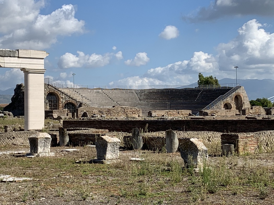
The Archaeological area of Minturnae is at kilometer 156 on the Appian Way, these the remains of the ancient city-port of Minturnae which was destroyed by Rome in 315 BC,.

It was rebuilt in 295 BC and again destroyed, this time by the Lombards, around 580 AD.

You can admire the Roman Theatre, an original section of the Via Appia in basaltic lava blocks, the remains of the Republican and Imperial Forums, the Capitolium (dedicated to Jupiter, Juno and Minerva), the market, the Tabernae (small indoor shops) and spa complex.

The theatre was built around the first century AD and is divided into three characteristic sectors (stage, orchestra, auditorium).

It welcomed over 4000 spectators and still today, in the summer, it hosts theatrical and musical performances. There is also a Museum.

Nearby are the numerous and impressive Roman aqueduct arches, visible for a distance of about 11 kilometers.

powered by social2s
Tarquinia. Necropolis of Monterozzi

The peculiarity of the Tarquinia necropolis are the painted tombs whose frescoes are the only such example of the great contemporary Greek painting, that have come down to us.

Of the approximately 200 Etruscan tombs with wall paintings, 140 are located in Tarquinia.

The tombs ranging from Orientalising age (late seventh century BC) until the end of the Roman Republican era (1st century BC).

This huge artistic and historical heritage is a UNESCO World Heritage Site.

The necropolis is located on Monterozzi plateau and has a width of about three kilometers and a length of about six kilometers.

It is divided into various zones: Calvary, First Archi, Second Archi, Scataglini area, Doganaccia.

powered by social2s
Soriano nel Cimino,Archaeological Area of ​​Selva Malano

The Archaeological Area of ​​Selva Malano in Soriano nel Cimino is of ​​great interest and is dotted with tombs of various shapes and sizes in the forest of Maiano.

One of the most significant "monuments" is the Rock of the Preacher a place probably used for the worship with crude engravings and a ladder going up to the top where perhaps there was an altar for worship. 

In the Selva are also the remains of a fortified building, perhaps a Benedictine abbey.
 

powered by social2s

The Archaeological Area of ​​Vulci is located in Montalto di Castro next to the coast north of Rome.

Vulci was one of the most important Etruscan and then Roman cities. In its necropolis many notable ceramic and painting artifacts have been found.

The city was important for maritime businesses for crafts and agriculture, and was already active in the eighth century BC. In the sixth century BC the local handicraft, with the additional influence of Greek manpower, produced ceramics, sculptures, bronzes, of excellent quality that reached the markets around the Mediterranean.

After the crisis of the fifth century BC, the recovery led to the construction of new public works and a temple built in the urban area.

In the second half of the fourth century BC Vulci started the rivalry with Rome and the struggles ended in 280 BC when it ceded to Rome most of its territories and the entire coast. The city declined rapidly thereafter until it disappeared altogether.

Among the remains of Etruscan and Roman phases are the walls, the doors to the city and the "Great Temple" originally from the late Archaic period, with base in blocks of tufa covered with molded blocks. The life of the sanctuary concluded around the end of the fourth century AD when the edict of Theodosius in 380 prohibited the pagan cults.

In front of the temple stood a spa and a late Roman basilica.

Along the "Decumanus", the main paved road running through the town, there are several Domus made between the late second and early first century BC.
In late antiquity, it became a part of a rustic villa and then was completely abandoned
 

powered by social2s
Archaeological Nature Park of Vulci

The Archaeological Nature Park of Vulci in Montalto di Castro has an area of ​​900 hectares in the heart of the Maremma Laziale and is crossed by the river Fiora.

Along the route of the river are numerous waterfalls and open inlets where the river forms small lakes: one of the largest is that of the Pelican.

The park has beautiful natural features, rich in olive plantations and vineyards.

In small valleys large areas of pasture open up, where you can meet Maremmane cattle and horses in the wild.

Inside the park there is the ancient Etruscan city-state of Vulci and many an Etruscan necropolis.


powered by social2s

Necropolis of Pianezze in Grotte di Castro is one of the necropolis of the Etruscan centre of Tyro that is found on the tufo heights known as "La Civita". Of this centre remain tunnels, cisterns and stretches of the defensive wall in large blocks of tufa.

The necropolis was in use between the sixth and fifth centuries BC, and there are 24 chamber tombs excavated into the tuff at multiple levels and with long access corridors.

The tombs have a SE-NW direction, with reference to the Etruscan religious beliefs to which the Northwest is to be attributed to the underworld deities.

Each tomb housed a couple of generations of a family.

powered by social2s
Canino. Necropolis of Vulci

The necropolis of Vulci in Canino is important for the large number and variety of painted Greek pottery, Attican pottery with black and red figures,.

The potteries were often created by famous painters of vases that have signed their work such as Eufronio, Nikosthenes etc.

The tombs are relevant for the size or layout, and artistic aspects.

The necropolis are set around the ancient city and the main are located in Ponte Rotto, Cuccumella, Cavalupo, Osteria, Badia Castle, Polledrara and Ponte Sodo.

The tombs cover a broad historical period and are varied depending on precisely the time when they were in use.

powered by social2s

The center of San Giovenale of Blera is one of the rare examples of Etruscan urban architecture whose name is unknown but it is known that it was under the influence of Tarquinia.

The discovery and the archaeological excavations took part under direction of the Swedish Institute and King Gustaf VI Adolf of Sweden.

The settlement dates back to the seventh century BC and was located on a long plateau of tufa stone at the confluence of two rivers, according to the usual selection criteria of the settled areas of the Etruscan and Faliscan populations.

The plateau was still inhabited in prehistoric times as indicated by the findings of groups of huts related to the Bronze Age and the Iron Age.

The Etruscan settlement is located just below the present village and only two excavation areas, east and west of the castle, were left open and protected by sheds so as to be visible.

Just below the castle wall you can access the large shed that protects the best preserved Etruscan settlement. A walkway allows the view from above and you can distinguish the plans of houses, wells, hearths and the route of an ancient road with ruts of wagons.

All this testifies to the extent of the settlement that occupied the entire plateau.

The moat of the castle cuts across the acropolis and there are remains of fortifications with large limestone blocks, built without mortar.

The area of ​​Juvenal was found almost by accident by the Swedish Institute of Classical Studies when starting their archaeological activities in 1956.

The aim was a simple fact-finding investigation and the results went beyond all expectations.

powered by social2s

Subscribe to Newsletter

Discover a territory through the emotions of the people that have lived it.